
Early detection of hitchhiking pests requires the identification of strategic entry points via transport. Our INRAE team has developed a framework for achieving this in continental Europe for the Japanese beetle. Human-mediated dispersal has been responsible for its introduction into several continents over the last century, including Europe where it is listed as a priority pest. Furthermore, interceptions far from the current infested area confirm the risk of unintentional transport within Europe. We analysed how three modes of transport - air, rail and road - connect the infested area to the rest of Europe. We ranked all European regions from most to least reachable from the infested area. We identified border regions and distant major cities that are readily reachable and observed differences between modes. Finally, we propose a composite reachability index combining the three modes, which provides a valuable tool for designing a continental surveillance strategy and prioritising highly reachable regions, as demonstrated by recent interceptions.
More about the methodology...
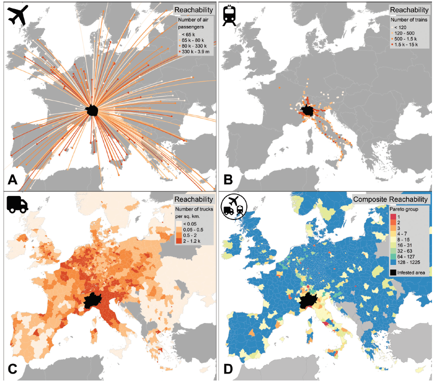
Our novel approach maps the potential human-mediated spread of the beetle from the infested area to the rest of continental Europe. We studied hitchhiking by targeting three modes of transport -air, rail, road- that are relevant to the beetle's pathways of entry from the infested area and for which comprehensive databases were readily available.
Our introduction risk assessment framework is based on three main steps. First, for each transport mode, we identified all source locations within the infested area (e.g. airports or railway stations). Then, we quantified the intensity of connections to all possible destinations elsewhere in Europe. Finally, we combined transport modes using a Pareto optimality method to rank regions according to their risk of introduction.
Reachability maps by the three transport modes, and composite reachability combining transport modes, are shown in the figure below. The reachability of regions varies by mode, and we detect topological features of transport networks, ranging from a local and national predominance (rail and road transport, panels B-C) to an almost exclusively international dimension (air transport, panel A). The proposed composite reachability index (panel D), which combines the three transport modes, highlights a few scattered highly-reachable major cities across Europe, as well as a cluster of high reachability comprising many regions of Italy, Germany, Switzerland and France surrounding the infested area.
Interestingly, all Japanese beetle interceptions that have occurred in Europe over the last 5 years have been reported in regions that our analysis identified as highly reachable, providing preliminary evidence of the robustness of our approach.
Find out more:
Borner L, Martinetti D, Poggi S (2024a) A hitchhiker's guide to Europe: mapping human-mediated spread of the invasive Japanese beetle. NeoBiota 94: 1–14. https://doi.org/10.3897/neobiota.94.126283
Borner L, Martinetti D, Poggi S (2024b) Data for "A hitchhiker's guide to Europe: mapping human-mediated spread of the invasive Japanese beetle". Recherche Data Gouv. https://doi.org/10.57745/3WUVWJ